ERCIM News 65April 2006Special theme: Space Exploration Contents This issue in pdf Subscription Archive: Next issue: July 2006 Next Special theme:
|
by Andy Smith, Mark Woods and Martin Townend
As our exploration of the Solar System moves from fly-bys and orbiters to close-up investigations, intelligent robots are increasingly coming into their own. This article describes how SciSys’ cutting-edge software aims to control two such expeditions.
Software is a key enabler of robotic exploration and has long been acknowledged as integral to the success of any space mission, whether it’s telecommunication, Earth observation, navigation, or space exploration. Today advanced software applications such as formation flying and autonomous navigation are often the driving force behind future space missions. SciSys is currently concluding several studies into the use of advanced on-board software for planetary exploration. This article describes two of these technology studies which are targeted at today’s proposed Mars / Moon missions, namely aerobots and rover intelligent planning and scheduling. An expert in on-board software for planetary exploration, Bristol-based SciSys is currently involved in many aspects of ESA’s Aurora programme, whilst recent space exploration missions in which SciSys has played a key role include Mars Express and Beagle 2, Rosetta, Venus Express, SMART-1 and Huygens.
|
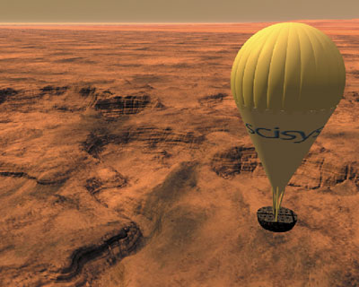
Planetary aerobots could transform the way we explore those planets and moons which support an atmosphere. Traditional orbiters offer a ‘bird’s eye view’ of the planet, covering vast swathes of land, with limited resolution. On the other hand, rovers or landers provide a highly detailed characterization of their local surroundings. Bridging this gap, the planetary aerobot can travel large distances whilst at an altitude which allows for the acquisition of extremely high resolution images.
An aerobot would carry a variety of sensors to collect data on the planet’s atmosphere and a camera system to build 3-D Digital Elevation Models (DEMs) of the surface below. By relating the information to images created by satellites, the exact whereabouts of the aerobot can be pinpointed. This is crucial for scientific understanding of an area as it allows scientists to piece together an accurate mosaic of a region using actual planetary latitude/longitude references. Such references can also be used to categorize and discover suitable landing sites for future missions for example.
|
SciSys, with the University of Wales, Aberystwyth (UK) and Joanneum Research (Austria), is currently developing and testing a vision-based software package which builds 3-D models and localises the aerobot using vision data. The project will deliver two main components, namely: an Imagery-based Localisation Package (ILP) module which will implement the on-board Digital Elevation Model (DEM) generation, image prioritisation, vision-based localisation, data storage and uplink management; and a test framework to validate and evaluate the ILP module. The test framework will include a dedicated software simulator and a real prototype balloon fitted with a comprehensive payload ie camera system, on-board computer, altimeter and wireless communications.
The ILP requires an advanced image prioritisation data management system since the aerobot would only be able to upload its data to the orbiting spacecraft at limited times. Image prioritisation is a process by which the ILP stores images which are, by a prior-agreed set of standards such as high gradient variability, judged to be of interest to the scientific community. Those which are of less interest may be compressed more substantially or simply not stored at all.
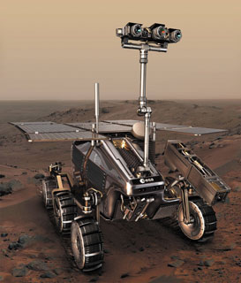
As Steve Squires, Principal Investigator for NASA’s Mars Exploration Rover (MER) mission, has commented “it takes MER a day to do what a field geologist could do in 45 seconds”. For a complex mission, there is a need to increase the intelligence of the On-Board Software (OBSW) so that it can perform more tasks autonomously without the need for ground assistance. There are a number of technologies from the field of Artificial Intelligence which can help out on future Mars missions. SciSys is currently carrying out research into Intelligent Planning and Scheduling (IPS) which offers engineers the prospect of having a rover which can validate their activity plans with real-time information and repair these plans autonomously should they fail. Ultimately therefore, it offers the prospect of more science.
The potential of IPS for an actual rover mission has never been demonstrated in a test environment representing ESA’s Aurora programme. The Mars Mission On-board Planner and Scheduler (MMOPS) project aims to address this. SciSys, with the University of Strathclyde (UK) and Heriot-Watt University (UK), are working on a project to develop an on-board IPS application capable of mission plan validation and repair. Trials involving engineering and operations personnel will then explore the benefits and optimal trade-off between factors such as autonomy vs. complexity, risk and net benefit to a mission.
As these examples illustrate, SciSys’ own experience with the complex and challenging task of robotic planetary exploration has shown that strong relationships with universities and research centres is a key element for success.
Links:
SciSys: http://www.scisys.co.uk
ESA’s Aurora programme: http://www.esa.int/SPECIALS/Aurora/
Please contact:
Chris Lee, Head of Sales and Marketing (Space Systems), SciSys Ltd, UK
Tel: + 44 117 971 7251
E-mail: chris.lee![]() scisys.co.uk
scisys.co.uk