|
|

| |
| < Contents ERCIM News No. 61, April 2005 |
SPECIAL THEME: Environmental Modelling
|
|
| |
Extracting Maximum Information from Airborne Remote Sensing
by Eon O'Mongain and LiamTuohey
Computerized systems for environmental assessment and decision support depend fundamentally on measurements from which the maximum amount of information must be extracted. Research on the case of airborne remotely sensed data is discussed.
There is an increasing need for local and regional government authorities to acquire computerized systems to assist in evaluating the current status of the physical environment in their area and in assessing the impact of proposed future developments. In general such authorities already have extensive environmental sampling programs (eg water characteristics at designated places on streams, rivers and lakes; air quality at specific locations; noise levels along certain roads) whose outputs must be incorporated in the new systems. Also to be incorporated are such data as population densities, patterns of transport usage including car ownership, agricultural practices and patterns, industrial development and so on. The computerized systems must include relevant models of various aspects of the environment (eg associations between water quality and population density, agricultural production and phosphate/nitrate levels, traffic and air quality, local weather patterns, social capital and car usage), and must be capable of incorporating new data sources and models in the future. The utility of such systems depends crucially on the quality of their input data, which involves maximising the information yield from available measurements. The particular focus of this article is on extracting environmental information from airborne hyperspectral measurements.
Spectral Signatures is a University College Dublin campus company which for several years has specialised in extracting environmental information on water quality and land productivity by means of optical instruments that have been designed and built in-house. Capabilities include in-vivo and non-contact sampling of water Chlorophyll content, monitoring of Suspended matter and Dissolved Organic Matter and other pigments for the water industry, and remote sensing (airborne) application of hyperspectral techniques for water quality and land productivity quantification and mapping.
Pigments are chemical compounds that reflect only certain wavelengths of visible light, which makes them appear "colourful". More important is the ability of pigments to absorb certain wavelengths. In particular, Chlorophylls are greenish pigments of which the most important for photosynthesis is Chlorophyll a. In general, since each pigment reacts with only a narrow range of the spectrum, there is usually a need to produce several kinds of pigments, each of a different colour, to capture more of the sun's energy. Typically, each hyperspectral sample consists of 512 measurements, collected by means of an airborne 'Portable Multispectral Imaging Spectrometer', of the irradiance reflectance at equally spaced intervals in the visible spectrum. Flight campaigns have been carried out over several inland lakes and adjacents lands, with many samples collected during each flight.
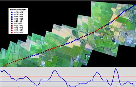 |
| Vegetation (Productivity) Index and Video Images of a Land Area. |
|
Traditionally, broad band ratio techniques, which would make use of just a subset of the available measured reflectances, have been used to convert multispectral measurements into estimates or indices of vegetative biomass or photosynthetic activity. An important part of the present work is the development of full spectral vegetation indices, with the aim of extracting the maximum amount of information from measurements. The figure provides an example of such an index, overlaid on simultaneously taken video images.
In general, absorption data contain chemical information while scattering data contain information on physical characteristics of particles. An important objective of the present research is to establish a systematic approach to extracting, from observations, maximum information on the ratio of scattering to total attenuation (scattering + absorption) in order to characterize lakes (and in-shore waters) comprehensively. The approach is to develop accurate mathematical models of the radiative transfer process, starting from classical solutions but drawing on modern tools such as Mathematica to make them more tractable (see, for example, Picard style iteration for anisotropic H-functions, W.G. Tuohey, Journal of Quantitative Spectroscopy and Radiative Transfer, In press January 2005).
In conclusion, the aim is to establish an accurate, reliable, easily updateable, and relatively inexpensive source of information on the environmental quality of water bodies and on the productivity of their catchment areas. This source would constitute a key underlying component of a computerized environmental evaluation system as described at the outset. In particular, a decision support system might include integration of this information source with in-situ measurements of environmental quality within or near waste water systems or discharges.
Link:
http://www.ucd.ie/spectral/
Please contact:
Eon O'Mongain, University College, Dublin, Ireland
Tel: +353 1 7162233
E-mail: eon.omongain@ucd.ie
Liam Tuohey, Dublin City University, Dublin, Ireland
Tel: +353 1 7008728
E-mail: ltuohey@computing.dcu.ie
|
| |
|
|