OASI: Integrated Monitoring and Decision Support for Environmental Systems
by Roberto Mastropietro, Lorenzo Sommaruga and Andrea E. Rizzoli
OASI is a system for regularly and automatically collecting environmental data from a network of hundreds of sensors distributed throughout the Canton of Ticino in southern Switzerland. It has been in successful operation for several months.
Canton Ticino is the southernmost part of Switzerland and it lies right on one of the most important European transport axis, connecting Italy with Central Europe. It is a sub alpine region, with remarkable natural beauties, but its environment is subject to many pressures, among which road emissions play a major role. In 2001 the Swiss government decided to tackle the problem of the growing traffic on the main national highways by funding initiatives aimed at making available the necessary data and tools to understand the impact of traffic on the environment, in order to enable policy makers to make appropriate decisions.
Within this context, the Land Management Department of Canton Ticino launched a project to develop an integrated monitoring and decision support system to collect, analyse and process multi-domain environmental data. The project outcome has been named OASI (Osservatorio Ambientale Svizzera Italiana), and was developed by SUPSI/DTI, the Department of Innovative Technologies at the University of Applied Science of Southern Switzerland.
OASI regularly and automatically collects environmental data from a network of hundreds of sensors distributed all over Canton Ticino. Then, the collected data automatically undergo a statistical, intersite and interdomain validation process before being made available to the end-users. In this process, past data, already validated, are used to detect anomalies in the measurements which have been recently collected.
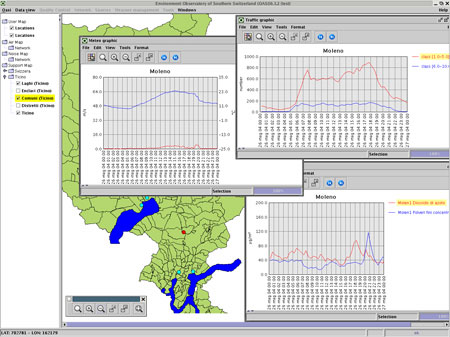
Scientists can access the data repository via the OASI application in order to perform integrated data analyses. Users can select locations, parameters, time intervals and diagram types. Multiple curves can be displayed and compared in a single diagram. Data belonging to different domains can be shown on a single screen, for comparison purposes, as shown in Figure 1.
The OASI software system has a scalable architecture that allows additional data domains, as diverse as basin levels and landslides monitoring indicators, to be seamlessly added to the set of monitored data. This is achieved thanks to its 3-tier architecture composed of a data layer, a logical layer and a presentation layer - and to a flexible database design.
Data from different domains are collected in separate databases in the data layer, but they can be transparently integrated for validation and analysis in the logical layer. The software architecture therefore easily supports the integration of multiple databases, and it allows the deployment of the system in distributed configurations making the solution flexible and scalable. The system allows the definition of user roles and data ownership. An organization may or may not allow its data to be seen or modified by users belonging to other organizations
One of the most challenging aspects of the project is related to the amount of measurements being collected and the size of the databases, which results in interesting storage management and system performance issues solved using special design and advanced techniques made available by the database management system (Andretta et al. 2004).
Finally, the presentation layer is designed to serve both the needs of scientists and researchers as well the general public that wants to be informed on the state of the environment.
The OASI system has been running in production mode for a few months and it has raised the interest of other Cantons that are now also integrating their data in the system for validation and analysis purposes.
Further developments of the OASI project will push towards the provision of an even more open and mobile access to data, supporting interoperability among different client-server nodes, easy extensibility for integrating any kind of client device into the system, both for regular users and system administrators. In particular, within the OASI context, Web services technology will be effectively exploited for integrating the needs for dissemination of analytical data about environment, such as air, noise, traffic, etc., and the needs of different users having accessibility requirements for their devices, being distributed and heterogeneous systems, remote and mobile clients (Arauco and Sommaruga, 2004).
Link:
Oasi website: http://www.ti.ch/oasi
Please contact:
Roberto Mastropietro, University of Applied Science of Southern Switzerland (SUPSI)
Tel: +41 91 6108578
E-mail: roberto.mastropietro supsi.ch