Getting the Most out of Earth Observation
by Martin Juckes
The imperative to understand our environment becomes ever more urgent as global change brings new uncertainties. At the same time, rapid technological advances are making it possible to observe the global environment from space in ever finer detail. In response to the challenges of handling an ever greater volume and diversity of data, the Multiple Instrument Stratospheric Tracer Assimilation (MISTA) project at Rutherford Appleton Laboratory has developed a new algorithm for extracting optimal information from satellite measurements. Thanks to gains in efficiency, a task normally done on supercomputers, can now be carried out easily on a PC.
Photons leaving the Earth's atmosphere carry the signature of the emitting gasses. Space instruments orbiting the Earth use a variety of filtering and detecting technologies to measure these photons and thence provide information which can be used to determine the state and composition of the atmosphere.
Imaging devices on geostationary satellites, measuring visible light reflected from clouds or solid surfaces, can give global coverage every 15 minutes or so. But this luxury is not available for those who want to study atmospheric composition in detail.
Our climate is significantly modulated by ozone, water vapour and methane in the stratosphere, all of which are present in concentrations of only 1 to 10 parts per million (106) by volume. Detection of the weak signal emitted by these gases requires satellites flying much closer to the Earth. Europe's environmental monitoring research satellite, ENVISAT, launched in 2003 at a cost of one billion Euro, is typical of this class of satellites, flying at around 800km altitude and orbiting the Earth every 100 minutes. The MISTA project has so far focused on results from one instrument on ENVISAT: the Michelson Interferometer for Passive Atmospheric Sounding (MIPAS). Of the three instruments on ENVISAT which were designed to detect stratospheric gases MIPAS has been the most successful to date.
The greater detail which can be obtained by instruments flying closer to the Earth is gained at the expense of losing the regular global coverage provided by the geostationary instruments. MIPAS provides a string of observations along the satellite orbital path. As the Earth rotates under the orbit a picture of the global atmosphere can be built up. However, many of the features which are observed evolve significantly over the course of a day because of physical processes, many of which are well understood.
A wide range of methods have been developed to combine the prior knowledge we have of the physical processes with the information stream coming from the measurements. The problem can be formulated in a Bayesian framework, combining observational information with prior information expressed in a computational approximation to the relevant physical laws. So far so simple, at least to those involved in this area of research. The novelty in this project is in the way it tackles the numerical challenges thrown up by the Bayesian framework. Many other research institutes working on the same problem are exploiting existing forecast models. These are computational representations of the physical laws designed to predict the future state of the system from a prescribed initial state. The MISTA project has started from scratch and developed code specifically designed for data analysis. This allows the full exploitation of the elliptical structure of the problem, a structure which follows naturally from a standard Bayesian formulation. A multigrid relaxation algorithm has been implemented. This type of algorithm is commonly used for the solution of elliptical partial differential equations, but has not been applied in this context before.
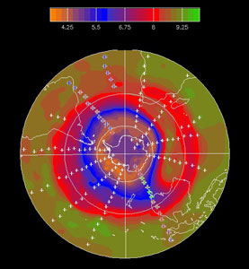
A particular advantage of the new algorithm is that it fully exploits observations both prior to and after an analysis time. Information propagates both forwards and backwards in time within the analysis system, with a typical half-life of around 2 days. This means that images such as the figure, which shows the ozone distribution in the stratosphere (at around 30km altitude) on July 6th, 2003, can be significantly more accurate than anything produced by a forecast system which, by its nature, can only exploit observations prior to the analysis.
Link:
http://home.badc.rl.ac.uk/mjuckes/mista/
Please contact:
Martin Juckes, British Atmospheric Data Centre Research,Space Science and Technology Department, Rutherford Appleton Laboratory, CCLRC
Tel: + 44 1235 445124
E-mail: M.N.Juckes rl.ac.uk