|
ERCIM News No.47, October 2001 [contents]
|
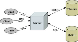
GeoNotes: Social Enhancement of Physical Spaceby Per Persson and Fredrik Espinoza Positioning technology is often associated with locating people in geographical space. The GeoNotes system, however, positions pieces of information. GeoNotes allows all users to annotate physical locations with virtual ‘notes’, which are then pushed to or accessed by other users when in the vicinity. GeoNotes started in the summer of 2000 and is an ongoing project at the HUMLE-lab at Swedish Institute of Computer Science. Although the final application will rely on systems that handle automatic positioning of mobile devices, the primary workload so far has been on the application side. Today GeoNotes is a Java application that allows a user to add content, a GeoNotes place label, sender information, and access restrictions. The user then chooses a lat-long to define the place of the GeoNote, either through a map interface or ‘here’. The base server handles transactions of notes for all clients (see Figure 1). It performs requests from clients to insert notes, retrieve notes from a location, and to update a single note. It stores the actual note data (its contents), be it text, audio, or video, as an entry in the Wherehoo database (http://wherehoo.media.mit.edu/). Wherehoo is a service for storing location dependent data in a client independent manner. It stores data coupled to a field that describes the physical location of the data as a latitude/longitude position. To retrieve data, one specifies the location and a radius and the service returns all entries in that area. The server stores meta information about the usage of the note, such as the number of times it has been read, when it was last read, and so on, as data in a MySQL database. GeoNotes is an open and mass-scale annotation system, allowing not only commercial or organizational annotators to add to the information space, but all users. In this way it is more similar to graffiti, toilet scribbles, sticky notes and posters than to commercial marketing channels. As a mass-scale annotation system we can expect public and private spaces to be cluttered with GeoNotes. These traces of other people create a nice social overlay over geographical space, and thus support social awareness and processes in those spaces. At the same time, however, information overload will become a problem, making navigation support and filtering the core foci of GeoNotes.
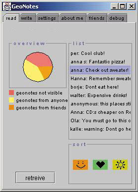
Users can browse a map for GeoNotes or use the at-a-glance overview displayed in Figure 2, which provides GeoNotes of the immediate surroundings. The size of the circle represents the number of GeoNotes at this particular place. The pie-chart represents different sorts of GeoNotes, for instance notes specifically directed to the user or relating to some content. At the right hand side of the interface, there is a scrollable list of all GeoNotes at this specific place. Once clicked, the user accesses the individual GeoNote. The next step in the implementation is to provide a search engine for GeoNotes (perhaps in combination with a map interface). GeoNotes pushed to the user will be filtered with social recommendation and collaborative filtering techniques. Information about users putting up notes, reading notes, rejecting notes or even rejecting GeoNotes senders (MacDonald’s advertisements, for instance), provide valuable information to profile the user and to cluster those profiles with other users’. In this way only those GeoNotes that are shared within such a cluster of similarity will be pushed to the user. Such filtering techniques can also be complemented with traditional word-based search engines: ‘only push GeoNotes that contain the words ONE-ROOM APPARTMENT or CAR FOR SALE’. Future activities of the project involve deploying the GeoNotes service on some positioning enabled PDA and conducting user evaluation. Link: Please contact: |