ESIMEAU - Information Technologies for Water Resources Management and Modeling in Semi-Arid Areas
by Fadi El Dabaghi
The increasing demand of freshwater associated to the decrease in water resources and the extensive use and pollution are calling for better design and optimal exploitation of hydro-systems. It is universally recognized that water resources problems are complex, characterized by the interaction of several physical phenomena, some of which we can not easily understand. Any effort to develop a solution for these problems, whether it is to preserve water for irrigation, or to manage a watershed, or to build a dam to alleviate flood problems or to oxygenate a lake to eliminate eutrophication problems must be based on an approach that considers all cause and effect relationships and evaluates in a systematic way the various alternatives.
Similarly to other decision support problems that deal with the environment, the appropriate way for doing this is the use of systems theory. That is an approach that accounts for the feedback among the various components of the ecosystem studied and which attempts to express mathematically the interrelationships that exist. Like in any engineering or science topics, when treating problems related to water resources the following has to be considered:
• Partial Differential Equations based governing equations involving parameters and/or coefficients that might be known or need laboratory or in situ experimental information for their evaluation
• phenomena occur in a geometric domain that can be a watershed, a lake, a river, etc
• well posedness is required (boundary and initial conditions are needed)
• Computer code for numerically computing the unknown variables using a numerical method (finite difference, finite element, finite volume based) therefore involving the so-called discretization or meshing of the domain through a pre-processor
• post-processing facilities.
Once a computer model built, one can then proceed to further simulations of scenarios that represent the user’s requirement and exploitation. However, the end user has to go through all the process, i.e. data analysis and data preparation for a model, domain meshing, computer simulation, post-processing and decisions. This is a bit cumbersome.
ESIMEAU Objectives
For the sake of illustration, within the ESIMEAU project, only surface water is considered. Important components of this framework are data and models. The data reflect the current and future conditions in the area studied, while the models are mathematical constructs that describe in quantitative terms the relationships that exist in the real world. Although mathematical models for water resources problems have been developed for some time, their use is not widespread, particularly in developing countries, because they are cumbersome to use and difficult to comprehend by people without extensive mathematical and computer background.
The main objective of ESIMEAU is to build an infrastructure of an integrated system to be used as a single decision support system for the management of water related issues. Such an open work platform will embody numerical models and simulators operating on spatial geographic databases, as well as data acquisition and data management tools. The direct beneficiaries are spatial planners and decision makers who will find through such a system, efficient operational facilities in the preparation and the installation of planning and/or emergency measures directly related to water – both as a sustainable resource and as a natural hazard – in general, and specifically for semi-arid areas. The main actions to be addressed are :
• develop or integrate tools for the management, analysis and treatment of heterogeneous data taking into account the semi-arid climate characteristics;
• model and analyse rapid phenomena such as floods and solid transport or slow scale ones such as eutrophication, erosion, climate change and develop appropriate numerical algorithms for a better and realistic simulation reproducing the real physical situation of the phenomena under investigation ;
• integrate these conventionally separately dealt with application domains into a single application through intelligent interfaces within an appropriate and user-friendly framework.
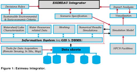
The architecture of the system to be developed will contain:
• general modules such as graphics, data base management systems (DBMS), geographic information systems (GIS), shells, simulators, etc which will constitute a part of the skeleton of the system
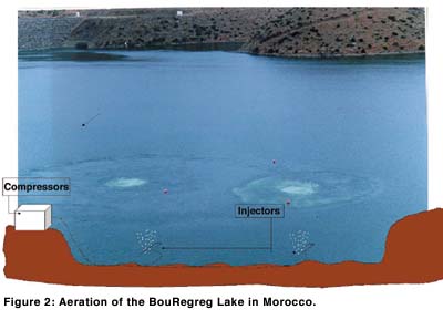
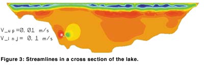
• specific modules taking care of particular physical applications (hydrology, hydraulics/hydrodynamics, eutrophication, etc.) are to be developed separately step by step. Within the framework of the present project, the numerical modules are focused on the mechanical treatment of eutrophication, the flood/release risk management occurring in watersheds will be limited to the state of the art for further numerical modeling.
A dynamic modular approach is adopted in order to integrate the various contributions of the partners in three main levels in an open generic platform characterized as follows:
• at the top level, the ESIMEAU integrator which will allow the end user without prior or deep knowledge about computer technology, to access and use within a user-friendly environment all the operational modules, data manipulation, model access, visualization, numerical simulation and post-processing including thematic maps
• at the intermediate level, specific modules for data treatment, and numerical simulation/prediction modules. These modules are developed following the general ESIMEAU architecture (Input / Output), and integrated whenever a task is finished and implemented.
• at the lower level, data access, consultation, modification and visualization interfaces.
For a good coherence, an efficient exchange and a positive collaboration between partners, the philosophy of work will be reinforced by specific Information Technology (IT) knowledge transfer parallel actions towards south partners :
• develop and implement methodologies based on Geographic Information Systems (GIS) for handling datasets for water resources management
• training and dissemination actions on the use of GIS packages such as ARCVIEW, and High Performance Computing (HPCN) as well as on numerical methods and modeling/simulation
• build the integrator WEB site devoted to the project for real time information on the development and progress.
As mentioned above, the water and/or environment national boards and/or specialized companies are the privileged end-users of ESIMEAU. Such a system is of crucial interest to them since it offers an evolutive generic platform based on an open global architecture. It is built with respect to various water issues and linking traditionally water resources aspects related to separate domains, specifically research and IT tools with socio-economic actions.
CruCID
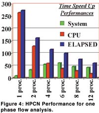
In addition to ESIMEAU, a demonstration project called CruCID will focused on the use of High Performance Computing and Networking in the modeling and simulation of flood wave propagation. The end users are organisms concerned with flood alert, inundation prevention, watershed planning and environmental impact studies, as well as institutions interested in HPCN platforms and the associated tools. The project will improve the capabilities of partners from developing countries related to the implementation and development of HPCN parallel computing, and its applications to engineering sciences. As for the European partners, CruCID (Flood Modeling using HPCN) will provide an opportunity to extend their research experience in HPCN techniques, usually devoted to high technology fields such as Computational Fluid Dynamics, to some important new environmental applications such water resources.
The parallel version(s) of the selected software from some available freeware ones, to be implemented within CruCID, will reduce drastically the computational costs and CPU times, which will allow the simulation of large scale problems and consequently provide more reliable results. Such HPCN based software could be the backbone of a flood alert system. The consortium will be opened to water agencies in charge of flood alert and protection.
The partners in ESIMEAU and CruCID are: ERCIM; INRIA; IACM-FORTH; IRD-Institut de recherche pour le developpement, France; RIKS-Research Institute for Knowledge Systems, The Netherlands; ENP-Ecole Nationale Polytechnique d'Alger, Algeria; ESIB-Ecole Supérieure d’Ingénieurs de Beyrouth, EUCLID, Lebanon; EMI-Ecole Mohammadia d’Ingénieurs, ONEP-Office National de l’Eau Potable, Morocco; CITET-Centre International des Technologies de l’Environnement de Tunis, ENIT-Ecole Nationale d’Ingénieurs de Tunis, Tunisia.
Links:
Please contact:
Fadi El Dabaghi - INRIA
Tel: +33 1 39 63 53 43
E-mail: Fadi.El_Dabaghi@inria.fr