Implementing a High Resolution Numerical Model of the Strait of Gibraltar
by Gianmaria Sannino, Roberto Conversano and Vincenzo Artale
The Mediterranean sea is a basin in which a wide range of oceanic processes and interactions of global interest occur. Intense evaporation over the Mediterranean Sea produces dense, salty water that outflows through the Strait of Gibraltar and can have an impact on the general circulation of the global ocean and particularly on the formation of deep water in the North Atlantic. One effect of the outflow from the Mediterranean is to make the Atlantic Ocean saltier than either the Pacific or Indian Oceans.
The Gibraltar Strait controls the entire fresh water budget of the Mediterranean sea and for this reason there has been both experimental and theoretical interest in the physics of the Strait and on monitoring the heat and flux on the sill. The existence of this strait makes the Mediterranean sea one of the few regions in the world's oceans where the advective heat and salt flow is known with sufficient accuracy to permit testing of the available data sets, the bulk formula and the model results of the surface heat flux. In recent years, in the context of the III and IV Framework, the European Community has financed a number of projects aimed at improving knowledge of the Mediterranean circulation from both numerical and experimental points of view.
In particular, one task of the MTP-II-MAST Programme (1996-1999) is dealing with the numerical implementation of a high resolution numerical model of the Strait of Gibraltar and its parameterization in the Ocean General Circulation Model.
Motivations
Since the beginning of the century the Strait of Gibraltar has been a favourite place for oceanographic studies. The dominant oceanographic feature of the Strait is a two-layer inverse estuarine circulation that is driven by an excess of evaporation over precipitation and river discharge into the Mediterranean. In addition, recent field experiments in the Strait have kindled a renewed interest in two-layer hydraulics and its role in controlling the mass transport between the Mediterranean and the Atlantic sea.
As a result of the effects of this hydraulic control, two possible states have been hypothesised for the Mediterranean Sea/Strait of Gibraltar system: 1) over-mixed with maximal exchange, minimum difference in salinity between the two layers and a shallow, supercritical inflow at the eastern end of the Strait, or 2) not over-mixed, with sub-maximal exchange, a bigger salinity difference and a thicker sub-critical inflow.
The Alboran Sea Circulation is dominated by the Atlantic water entering the Alboran sub-basin as a shallow buoyant stream that curves southward most of the time. It then forms a large anticyclonic gyre, which may extend throughout the whole width of the sub-basin.
From satellite observations the gyre seems to have some variability, generating a second cyclonic gyre up to the main stream. The anti-cyclonic/cyclonic structure at the end of the Strait may be related to the geometry of the basin. Observations have also revealed the appearance of a second anticyclone in coincidence with the Almeria-Oran front. The variability of this second anti-cyclonic gyre is more pronounced than that observed in the western side of the basin. These two-three gyres are considered to be one of the permanent features of the Western Mediterranean circulation and participate in the formation of the MAW (Mediterranean Atlantic Water). The precise criterion for the anti-cyclonic/cyclonic features of the Alboran sea are still unknown.
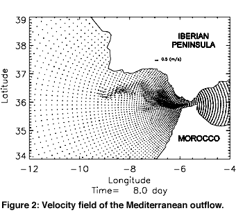
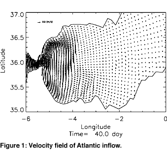
The numerical simulation that we show in the figures refers to the evolution of the Atlantic water into the Alboran basin and the outflow of the Mediterranean sea into the North Atlantic circulation. Figure 1 shows the Alboran gyre circulation and the Mediterranean outflow at depth. From a first analysis of these results we note a good agreement with the observations. However more experiments and analyses are needed to evaluate whether the resolution of the model is sufficient to describe this phenomena. In particular, we hope that our numerical experiments will answer a number of questions, such as:
- is there a permanent hydraulic control site in the Gibraltar Strait and, if so, how does it depend on seasonal variations in the Mediterranean basin?
- What are the principal forcing effects (tide, topography...) that can generate the variability of the ocean current along the coast of Portugal and the bifurcation of the Mediterranean outflow at Cape Saint Vincent?
- What are the physical mechanisms that generate gyre variability in the Alboran circulation?
The numerical simulations were performed using POM (Princeton Oceanographic Model) a primitive equation numerical model. The model was initialized with climatological salinity and temperature without wind stress forcing. The boundary conditions are computed by the Newtonian relaxation terms at the boundary domains of the model using the monthly temperature and salinity climatological data. The model runs on the Digital 4100 parallel platform or on a CRAY J90.
For more information, see the project Web site: http//www.cetiis.fr/mtp/mater
Please contact:
Vincenzo Artale - ENEA
Tel: +39 06 3048 3096
E-mail: artale@casaccia.enea.it