Image Analysis of Deformable Structures - A Meteorological Example
by Hussein Yahia and Jean-Paul Berroir
The segmentation of deformable structures is an important task of image analysis. Satellite image sequences provide a huge amount of data often displaying the temporal evolution of complex structures, like clouds in the atmosphere on meteorological data. Structures like clouds and vortices are also subject of fusions, or can dissolve themselves into many connected components. Powerful deformable models, like the level-sets methods, are steadily gaining ground in image analysis and computer vision. In the research conducted in the AIR project at INRIA-Rocquencourt, a new characterization of level-sets by particle systems is achieved, leading to models that can be interactively controlled by an operator and permit the modeling of complex visco-elastic structures in motion. The control of level-sets by particle systems gives the possibility of using fast numerical resolution algorithms. It also features the attractive property of assigning specific internal or external energies to the level-sets, simply by prescribing particular forces on the finite set of particles. It also gives the possibility of analyzing motion.Geostationary satellites may be used to collect input parameters of meteorological forecast models: winds are computed from the observed clouds displacements; their estimation is based on the cloud motion analysis at various altitudes. The study of clouds for themselves, ie their displacement during their life cycle, is also a very important topic. For instance, the typical western European climate is dominated by oceanic influences. Vortex formation over the atlantic ocean is therefore of paramount importance to weather forecast. It is characterized by a very specific motion: the cloud structure is winding round its center, yielding a spiral-like shape. The whole structure also undergoes a fast translation, eastward in the case of European weather analysis. Another example is found in the Western African climate, which is influenced by the intertropical convergence area: it is a location where dry air (trade winds) meet wet air carried by the African monsoon. This usually generates (in August) a more or less continuous area of cumulo-nimbuses, that yields approximately 80% of the Sahel and Sudan water supply. The cloud motion in this area is highly perturbated: on top of a steady westward translation, intensive activity of clouds causes them to merge or to break up. Analyzing clouds is then very important for precipitation forecast. Cloud structures or vortices are deformable structures subject to large deformations, and their analysis requires the use of segmentation models allowing topological changes and visco-elastic behaviours.
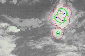
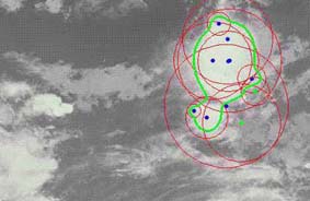
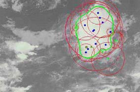
Among the various deformable models for image segmentation in computer vision, level-sets methods have drawn particular attention, mainly because they offer the ability of modeling large deformation, and topological changes. In the research conducted in the AIR project at INRIA, the level-sets are represented by particle systems. The implicit function is described by a finite set of control points, or particles, onto which specific internal and external energies are assigned to offer a precise control of visco-elastic behaviours. The internal energy is defined by specific potentials describing the elastic properties of the level-set. The external energy produces a force field applied on the particles which attract the level-sets towards the extracted contour points. Using a particles system leads to fast and robust minimization techniques, and permits hierarchical refinement. The global shape is described by few particles, and new control points are added at specific locations where more precise representation is needed. The result of the minimization process is an iso-contour whose shape is interactively manipulable by the user. The implicit function defined this way can be processed in specific monitoring systems, and the result of the segmentation can be incorporated in meteorological database systems to provide specific representation of structures in motion. The use of dedicated internal energies provide the grounds for the use of these techniques in various applicative models. This particle system formulation is also useful for the initialization of the level-set. The use of skeletons and distance maps provide robust initializations, consistent with affine motion. Figure 1, 2 and 3 display the result of the segmentation in an image sequence of cloud structures over Sahel.
Figure 1: Initialisation on the first image of the sequence.
Figure 2: Result of the minimization.
Figure 3: Result on the next image of the sequence.
Image sequence by courtesy of Laboratoire de Meteorologie Dynamique, Ecole Polytechnique, France.AIR project is dedicated to the image analysis of satellite data for environmental problems. The image analysis of natural environmental problem needs different set of tools that can be applied in different applicative context. With different studies performed on snakes and level-sets, the research team is setting up different kinds of segmentation and modeling tools that are going to be used in different european research contracts under way. For more information on the AIR project, see: http://www-air.inria.fr
Please contact:
Hussein Yahia - INRIA
Tel: +33 1 3963 5357
E-mail: Hussein.Yahia@inria.fr