ERCIM News 65April 2006Special theme: Space Exploration Contents This issue in pdf Subscription Archive: Next issue: July 2006 Next Special theme:
|
by Martin J. Bates, Peter M. Allan, Brian Coan, Andy Smith and Brian C. Stewart
Determining the pointing of a telescope to 0.4 arcminutes might not seem unduly arduous, but when the telescope in question is on a satellite rotating at 100 rpm and subjecting it to a loading of 16g, then things become a little more difficult. This is one of the challenges faced when processing data from the Geostationary Earth Radiation Budget Experiment (GERB), a climate instrument on board EUMETSAT’s Meteosat Second Generation (MSG) series of weather satellites.
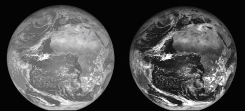
The first GERB instrument was launched on the MSG-1 satellite (now renamed Meteosat-8) in August 2002. The second in the series of four has recently been launched, in December 2005. GERB exists to make high accuracy broadband (total energy) measurements of the visible and infra-red radiation emitted by the earth. MSG is in a geostationary orbit, and GERB’s 18° field of view covers the entire Earth disk, building up an image from 282 x 256 individual pixel measurements. GERB is the first radiation budget experiment to be sited in geostationary orbit, and hence the first to make repeated measurements (every 17 minutes) of the same area of the globe. The GERB instruments are positioned close to 0° longitude and hence view Europe, Africa and the Atlantic Ocean.
GERB data processing is carried out in near real time by a distributed ground segment, with a first stage of processing (level 1.5) carried out at the CCLRC by the GERB Ground Segment Processing System (GGSPS), and higher level processing (level 2) performed at the Royal Meteorological Institute of Belgium (RMIB):
All communication with the satellite is carried out through the Mission Control Centre at EUMETSAT in Darmstadt. Imperial College handles GERB instrument commanding and operations, and leads the GERB International Science Team.
The GERB pixel size is approximately 44 km at the sub-satellite point, but in the GERB processing the position of each pixel must be located to an accuracy of about one tenth of this. This is because of the need in higher level processing to co-locate the GERB data with data from the Spinning Enhanced Visible and Infra-Red Imager (SEVIRI) instrument, a multi-channel instrument which is the main imager on MSG and is used in operational weather forecasting. This latter instrument produces images at higher spatial resolution (3km), and is used in the level 2 GERB processing for scene identification and spatial resolution enhancement.
This sub-pixel accuracy requirement means that the GERB pixels cannot be geolocated using the GERB image alone. Instead, the following information is used:
However, MSG is a spin-stabilised satellite: it uses its own angular momentum to maintain a stable orientation in space. MSG rotates at 100 rpm, and this produces a number of complications.
A ‘Start of Line’ (SOL) pulse is generated by the satellite on each rotation. It is designed to arrive a fixed time before the Earth passes the instrument viewing window, and it acts as a ‘get ready’ signal to the onboard mechanisms. However, the timing of this pulse can vary from its nominal value, due to the tilt of the satellite and the performance of the Earth and Sun sensors which generate the signal. The GGSPS uses timing corrections generated by the IMPF to compensate for drifts and fluctuations in the SOL pulse.
MSG’s rotation means that the earth flashes past the GERB instrument nearly twice a second. However, to make a measurement, GERB needs to hold a steady image for 40 milliseconds. GERB uses a de-spin mirror, rotating at half the speed of the satellite and in the opposite sense, to achieve this. However, this requires the MSG spin axis and that of the de-spin mirror to line up precisely. Any misalignment can cause a shift and a blurring of the image in a north-south direction. This alignment can change with time, due to thermal effects and the burning of fuel by the satellite, and work is ongoing to track and compensate for these changes.
|
The GERB instrument is placed near the outside of the 3.2 m diameter MSG satellite, where at 100 rpm it experiences a loading of approximately 16g. This places large stresses on the instrument, particularly on the de-spin mechanism, and also causes structural distortions, both to the GERB instrument itself and to the platform on which it sits. The de-spin mirror position is monitored more than 100 times during the acquisition of each Earth measurement, and the amount of blurring resulting from non-uniform motion is estimated and accounted for in higher level processing. The GERB pixel pointing directions were measured on ground from laser measurements: comparisons with SEVIRI images suggest that these pointing directions have been distorted by the 16g loading, and corrections have been derived. The GERB instrument is placed on shims to correct for the predicted bending in the platform on which it is located.
Further work is required to account for shifts in the relative alignment of the MSG and GERB spin axes, but geolocation accuracies better than 0.5 GERB pixels are currently being attained. Improved accuracy has been obtained by matching SEVIRI and GERB images as part of level 2 processing at RMIB, and this will form the basis of an initial data release in spring 2006; both methods will continue to be developed over the coming months to enable the target geolocation accuracy to be reached in a second data release.
Acknowledgements
This work would not have been possible without the help of colleagues at EUMETSAT, Imperial College and RMIB. The GERB instruments have been built by a European Consortium which includes RAL, Imperial College, Leicester University, the National Physical Laboratory and RMIB, as well as industrial partners in the UK, Belgium and Italy. The first GERB instrument was funded by the United Kingdom Natural Environment Research Council (NERC), together with funding agencies from Belgium and Italy. Development of the GGSPS, and its operation for the first GERB instrument, have been funded by NERC and the European Commission (Framework IV). Subsequent GERB missions are being funded by EUMETSAT.
Link: http://ggsps.rl.ac.uk/
Please contact:
Martin Bates, Space Science and
Technology Department, CCLRC, UK
E-mail: m.j.bates![]() rl.ac.uk
rl.ac.uk