ERCIM News 65April 2006Special theme: Space Exploration Contents This issue in pdf Subscription Archive: Next issue: July 2006 Next Special theme:
|
by Christian Barbier
Synthetic Aperture Radar (SAR) image formation and its exploitation are the subject of intensive research at the Centre Spatial de Liège.
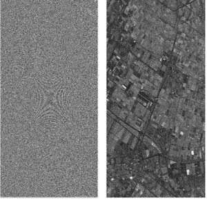
SAR is an active, microwave radar imaging technique that has the ability to provide high-resolution images of the Earth and planetary surfaces, independently of solar illumination (ie day and night) and cloud cover (ie in all weather). Contrary to classical visible-light imagery, extensive processing, referred to as aperture synthesis, focusing, or reconstruction, is required to convert the raw image into an intelligible image (see Figure 1).
|
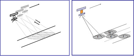
The two fundamental dimensions in an SAR image are slant range (perpendicular to line of flight) and azimuth (parallel to line of flight). Target discrimination in range involves the correlation of each echo with the corresponding transmitted pulse. In ‘classical’ Stripmap SAR imaging, high azimuth resolution (typically 10m) is obtained by integrating successive echoes from a given target over the time interval during which the target is illuminated by the radar beam. This results in the synthesis of an antenna with an effective azimuth aperture of up to several kilometers. An increase of the swath width can also be made at the expense of azimuth resolution, by periodic switching of the radar beam between adjacent sub-swaths. Medium- (150m) to low- (1000m) resolution images can be obtained using this so-called ScanSAR imaging mode (Figure 2).
|
A frequency-domain, phase-preserving SAR processor has been developed for reconstructing full SAR images. This processor is also capable of generating quick-look, low-resolution SAR and ScanSAR images directly from raw data. It will be an integral part of the ground processing chain of the Argentine SAOCOM satellite, which will carry a full polarimetric L-band SAR as the primary payload.
In addition to its amplitude, which yields traditional imaging, the SAR signal is also characterized by a phase and a definite polarization status, both of which allow additional information channels.
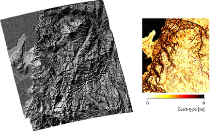
Exploitation of the phase channel yields the SAR interferometry (InSAR) technique, typical products of which are digital terrain models and terrain displacement maps (Figure 3). An interferogram is generated from two phase-displaced SAR images of the same scene, acquired from two neighbouring orbits of the carrier satellite. Provided the phase difference between corresponding pixels is only determined by the optical path difference (which is the case if, among other conditions, the observed surface and the atmosphere do not vary in time between the two passes), altitude information can be extracted from the interference pattern. An InSAR processor was developed and demonstrated based initially on ERS-1/2 imagery, and then on RADARSAT, JERS, and ENVISAT data. It will also be part of the SAOCOM package.
Time variations of the surface three-dimensional structure at a centimetre or sub-centimetre scale can be detected by comparing SAR interferograms at different epochs (differential SAR interferometry - DInSAR).
|
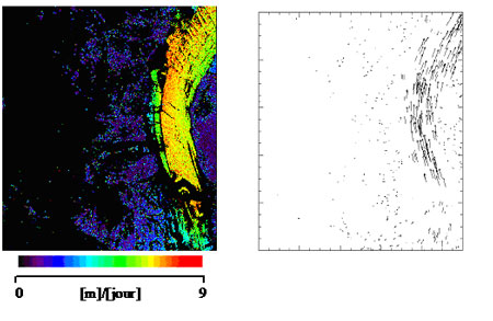
DInSAR also allows displacements to be measured with a very high accuracy, but only along the line of sight. To circumvent this limitation we have developed a method now known as coherence tracking. This technique is based on local coherence maximization, which is used in the co-registration process to generate a map of local azimuth and range displacement with respect to the global co-registration. This is managed with sub-pixel accuracy, and was successfully applied in a glaciology study (Figure 4).
|
Exploitation of the polarization state (SAR polarimetry – PolSAR) provides information on the backscattering mechanisms underlying echo formation. InSAR and PolSAR can be combined to form a new advanced processing technique known as polarimetric SAR interferometry (PolInSAR). Both PolSAR and PolInSAR are the subject of intensive research at CSL.
Links:
Excellent SAR tutorials can be found at the following addresses:
Alaska Satellite Facility scientific SAR User’s Guide: http://www.asf.alaska.edu/about_sar/about_sar.html
ESA ENVISAT/ASAR Product Handbook: http://envisat.esa.int/dataproducts/asar/CNTR.htm
Please contact:
Christian Barbier, Centre Spatial de Liège, Université de Liège, Belgium
E-mail: cbarbier![]() ulg.ac.be
ulg.ac.be