

ERCIM News No.44 - January 2001 [contents]
ERCIM News No.44 - January 2001 [contents]
by Leila De Floriani, Paola Magillo and Enrico Puppo
Multiresolution models have become very popular during the last few years to manage the increasing complexity of surface and volume data visualization. This topic is the subject of several research projects carried out by the geometric modelling and computer graphics group at the Department of Computer and Information Sciences of the University of Genova. Major applications concern terrain modelling in the context of Geographical Information Systems, 3D object modelling, and volume visualization.
The resolution of a geometric model is related to the number of primitives used to represent the details of a shape. Resolution has an impact both on the accuracy of the representation (thus, on the similarity of the model to the real object) and on the size of the data structures (thus, on computational efficiency).
Modern tools both for acquisition of geometry from real world, and for computer-aided design, can provide models at very high resolution. These models are very accurate but often too large to be effectively used in rendering, especially at an interactive rate. Multiresolution refers to the possibility of representing a spatial object at different resolutions, trying to balance the opposing issues of having sufficient accuracy and small size.
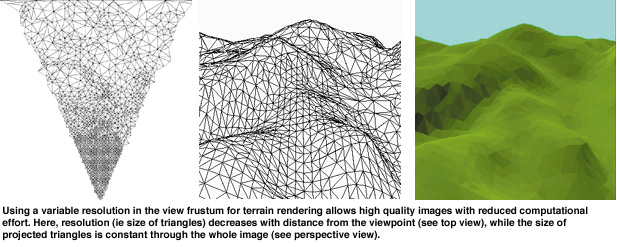
The key idea is that usually high resolution is not needed everywhere; the level of resolution can be variable in space and time. For instance, a three-dimensional scene can be rendered using a resolution which is higher near the viewpoint, since many details are required only close to the observer; in an interactive visualization program with a moving viewpoint, the resolution should be adapted dynamically.
Variable resolution is crucial, eg, for real-time visualization in virtual reality (aircrafts, ships, buildings...), scientific data visualization (three-dimensional fields such as temperature, pressure...), geographic information systems (terrain), medicine (volume data from TAC, SPECT...).
Since the production of a model at a specified (variable) resolution is computationally expensive, a multiresolution model is built off-line as a comprehensive structure which organises several pre-computed resolutions and supports a fast on-line combination of different resolutions into a single model, according to user parameters.
The DISI research group has developed the Multi-Tesselation (MT) model, a general multiresolution model for spatial data that does not depend on:
The MT model can be specialised for specific types of data, construction processes and/or operations, leading to very efficient implementations in those specific cases.
We have recently released a software library implementing the MT model (see http://www.disi.unige.it/person/MagilloP/MT/), which is intended as a general tool for supporting variable resolution in geometric applications.
MT has been used as a basis for: VARIANT, a prototype system for terrain modelling, which supports variable resolution; and TAn2, a system for scientific visualization developed in collaboration with the Visual Computing Group at CNR in Pisa (Italy), which can render huge three-dimensional data sets thanks to a multiresolution approach.
Links:
Geometric Modelling and Computer Graphics group, University of Genova: http://www.disi.unige.it/research/Geometric_modeling/
Please Contact:
Paola Magillo - DISI University of Genova
Tel: +39 010 353 6705
E-mail: magillo@disi.unige.it