MARVINS - Mobile Augmented Reality Visual Navigational System
by Raghav Sanwal, Sepideh Chakaveh, Konstantinos Fostirpoulos and Horst Santo
A solution for museum guides or training in dangerous environments was developed at GMD Institute for Media Communication.
To acquire information has never been cheap. Moreover until recently time was not a significant element when costs of information were being calculated. Nowadays, information acquisition time factor has taken on greater significance, and consequently provided an incentive for the development of technologies to facilitate the minimum time costs. The business sector has not yet been significantly concerned with the increased monetary costs of these time saving information technologies. A perfect example is the rapid adoption of live video conferencing, despite its initially high costs.
In other fields, such as education and tourism however, the situation is quite different. Here, the information seekers are generally individuals, schools or other organisations which normally hold rather limited funds. Consequently, they have been forced to adhere to the time worn and inexpensive methods of information acquisition such as pamphlets, brochures etc. or recently supplemented by the vast resources of the Internet. Nonetheless the Internet bears an inherent drawback, i.e. its inability to be a personal, customised, on-site and subject specific interface medium contrary to a teacher or a guide.
A fairly non-expensive system named MARVINS (Mobile Augmented Reality Visible Navigation System) eliminates this drawback. MARVINS is a mobile interactive interface between the user and the Internet or other information access points which can selectively display any desired information allocated at some remote server.
 Implementation
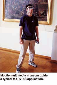
MARVINS is a simple Augmented Reality Assembly, primarily designed for mobile applications, which is implemented at a rudimentary level for test purposes. The complete system consists of a DynaSight tracking system, a Sony GlassTron, a transmitter and receiver set, and a computer. In addition the whole assembly is tracked using the line-of-sight principles. Information (Video, Audio and Text) is relayed from a server via the transmitter-receiver to the GlassTron Head-Mount.
A tracking system is used to provide orientation and navigation possibilities. The sensitivity of DynaSight tracking system is limited by the speed of any moving target (Lock-on delay: 0.3 sec, Measurement Latency: 16-31 millisec.). This is also a function of target’s relative position with respect to a three-dimensional co-ordinate plane centred midway between its two near infra-red tracking beams. The tracking system´s angular active field of cone, is some 75-degrees with respect to the origin of the co-ordinate’s plane.
Using three similar tracking systems to provide accurate tracking in a four-sided room, one may reduce considerably, the limitations on the field of sensitivity of the tracking system. For larger physical areas, normally Global Positioning Satellite (GPS) technology could be used.
The head mount unit used for MARVINS is a Sony Glasstron. The system renders the eye-screen opaque for viewing displayed information, as well as transparent for viewing with the naked eye, which can be adjusted accordingly. Glasstron is also devised with Stereo headphones for audio transmission.
The system was completed by cascading a transmitter-receiver set, operational in 1.2 GHz range. The video and audio signals generated by the server were directed to the transmitter- receiver set, which in turn forwarded the signals to be broadcasted to the head mount unit. It was found that a significant loss of clarity does not occur in either the video or audio. This would, of course, depend on the distance between the transmitter and receiver, and transmission range. The disadvantage of the Glasstron head-mount is its small viewing area, which consequently generates difficulties in reading fine scripts etc. (Dimension units 149x48x86 mm).
Further tests were carried out by adding some tracking systems. It was found that MARVINS could accurately track movements of the user’s head. However, the limitation recorded here was again the field of sensitivity of the tracking system. Apart from the lateral area of sensitivity, at distances in excess of an 8-feet radius, the information on the display did not change. It was found that the tracking readout would need to be modified to correct for distance from the viewed object. This correction would need to be incorporated into the final readout from the tracking system before the information or image were displayed. In this case, the display would reflect the actual
line-of-sight.
Possible Applications
Tourism: It is likely that the tourism sector will rapidly embrace this technology. Here, tourists may be provided with such a visual display and could freely wander and receive the audio-video information remotely from a server. An incentive is the boost to tourism that such a technology can provide.
Education: It will be a while before MARVINS is seen extensively in the educational sector at large. While the prices for such units are within the budgets of holidaymakers, they would normally exceed those of schools and small universities or even are assumed redundant. Nonetheless such systems may be used in areas, such as science museums, art museums and other historic or cultural sites.
Rescue Operations, Training and Simulations: MARVINS can be used for fire fighting and other hazardous activities. It can provide a definite edge where the latest information, directions, advice may be continuously updated in real-time. MARVINS´ fairly lightweight and portability make it ideal for rescue operations. It can also be used for training and simulations, functioning as a link between the training instructor and the trainee.
Please contact:
Sepideh Chakaveh - GMD
Tel: +49 2241 14 2608
E-mail: sepideh.chakaveh@gmd.de
