Land Use and Wind Estimation as Inputs for Air Pollution Modelling
by Dominique Bereziat, Jean-Paul Berroir, Sonia Bouzidi, Isabelle Herlin and Hussein Yahia
This presentation investigates the use of remote sensing image processing techniques to estimate input data for air quality models. These models actually use a lot of input data, whose collection can be inaccurate or costly. Thanks to their high spatial and temporal resolutions and their rich spectral content, remote sensing data can be analysed to estimate some input data in an objective and accurate way. This research is led at INRIA (AIR project) in collaboration with GMD Institute for Computer Architecture and Software Technology (FIRST), Berlin within the ERCIM working group Environmental Modelling.
Air quality models require a lot of different input data. The collection of this data can be inaccurate or costly and is one of the major limitations to the operational use of air quality models. Remote sensing data have a great potential to enhance input data collection thanks to their high spatial and temporal resolutions and rich spectral content. Remote sensing data can be analysed to estimate input data in an objective and accurate way.
Input data required by air quality models can be classified into three main branches:
- site documentation data give information about the site's orography and land use; remote sensing techniques can be used to produce these data automatically, thus making the adaptation of a model to a new site easier
- model initialisation, boundary conditions and synoptic data include cloud cover, wind profiles, soil temperature; these data have to be known very accurately when running a forecast or a simulation; they are however estimated from a sparse net of ground stations, and the use of remote sensing data for their estimation has not been evaluated yet
- model parameterisation data include the values of the various physical parameters involved in air quality modelling, for instance surface characteristics (temperature diffusivity, emissivity, albedo, aerodynamic roughness length). These parameters are most often assigned a constant value according to the land cover, regardless of seasonal changes and spatial variability. Here again, satellite data can be used to achieve an objective parameter estimation.
In the following, we briefly detail three examples showing the ability of image processing techniques to estimate input data for air quality models: land use spatio-temporal mapping using meso scale and high resolution data; wind estimation by optical flow techniques; and cloud cover estimation using deformable particle systems for cloud tracking.
Land use mapping has already been widely assessed and some techniques such as maximum likelihood classification now belong to the state of the art. However, these techniques produce a static land use mapping and do not take into account the effect of seasonal changes. Consequently, it is not possible to estimate varying surface parameters. For instance, the vegetation index (NDVI) evolves during the seasons and this parameter greatly influences surface characteristics such as aerodynamic roughness length. Meso-scale optical sensors (NOAA-AVHRR or VEGETATION) provide interesting surface measurements on a daily basis, but with a coarse spatial resolution (1km). Each pixel therefore contains different types of land cover. Pixel unmixing is a technique allowing to estimate the daily reflectance of each type of land cover, provided the land use is known at high spatial resolution on some selected learning sites. An interesting result is that it is possible to map land use on the basis of the temporal behavior of land cover. For this purpose, we have developed a data fusion scheme between high resolution (SPOT-XS) and meso-scale (NOAA-AVHRR) sensors to map land use with both high spatial and high temporal resolution. See an example on figure 1.
Wind can be estimated using meteorological sensors (eg METEOSAT) that output images every 30 minutes, thus making it possible to capture the apparent air displacement. The most popular technique to analyse motion on image sequences is called optical flow. It is based on the hypothesis that the intensity of a moving pixel remains constant during time. Expressed in a Euler-Lagrange framework, this hypothesis makes it possible to design a numerical scheme that yields dense velocity -or wind- fields. This assumption is however unrealistic when analysing cloud displacement. A specific model has been developed for that purpose: we state that the volume of the air column under the clouds remains constant over short periods.
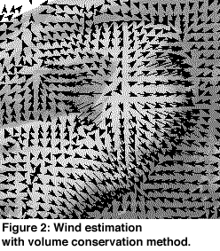
This assumption leads to a new equation close to the optical flow constraint, with an additional term that models the variation of the clouds' area. Results are better than those obtained using optical flow, since the clouds' expansion is correctly estimated (see figure 2).
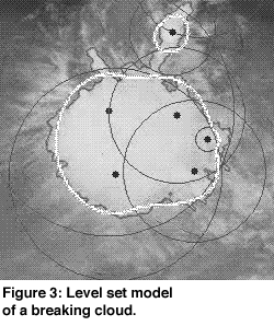
Deformable structures tracking, when applied to clouds, is a technique that makes it possible to estimate cloud cover with a good accuracy. The difficulty is that clouds usually undergo very important deformation during their motion, they can even split or merge. This causes most classical tracking methods to fail. We have developed an adapted deformable model, based on a particle system controlling a level-set, that models the cloud's boundary. This model is governed by an internal energy -controlling the elastic behavior of cloud motion- and an external one -controlling the adequacy between the model and the image data. This model is able to trackclouds even in the case of topological (split and merge) changes and even if the motion is fast (see figure 3).
As shown by the three examples above, image processing techniques applied to dynamic remotely sensed data can be successfully used to estimate relevant input data for air quality models. Future perspectives concern the evlauation of these techniques with regards to the gain in model accuracy and model automation.
Please contact:
Isabelle Herlin - INRIA
Tel: +33 1 3963 5621
E-mail: Isabelle.Herlin@inria.fr