Descartes System - Interactive Intelligent Cartography in Internet
by Gennady Andrienko and Natalia Andrienko
Descartes assists users in the exploration of spatially referenced statistical data, ie economical, demographic or ecological data related to geographical locations. It incorporates knowledge about thematic cartography to automatically generate thematic maps that correctly visualize selected data. It also supports the further, interactive exploration of these maps. Descartes was formerly called IRIS (see 'IRIS generates Thematic Maps' by Hans Voss in ERCIM News No. 27, October 1996).
Current Geographic Information Systems (GIS) specifically support the analysis and manipulation of geometric information. However, they are weak regarding their support of visualizing spatially referenced statistical data. Major shortcomings are:
- Users bear full responsibility for a correct selection of presentation techniques. Consequently, they must proficiently know principles of cartographic presentation, have to spend considerable time and efforts for map production, and cannot entirely concentrate on their task of analysis and problems to solve.
- GIS are typically complex and difficult to operate; significant training is required.
- GIS do not sufficiently support the further exploitation and exploration of produced maps, ie their use in data analysis. Descartes overcomes these shortcomings. It provides intelligent mapping support and a wide spectrum of functions for interactive visual data analysis.
Intelligent Mapping in Descartes
Descartes incorporates the knowledge on thematic cartography in the form of generic, domain-independent rules. To choose automatically the adequate presentation techniques for data selected by the user, Descartes accounts for data characteristics such as types of data fields (numeric, categorical, or logical), value ranges, and relations among the fields such as comparability, hierarchical inclusion, or their covering a meaningful whole (eg male and female cover the set of all persons).
Interactive Visual Data Analysis
Maps on computer screens should not be mere reproductions of paper maps, rather they should be dynamic and reactive to user's actions. Descartes provides various tools to interactively manipulate the maps so as to make them more expressive and to exploit the potential of specific visualization techniques for data exploration.
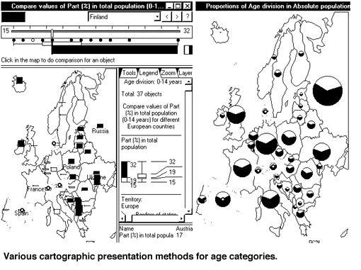
An example is the visual comparison technique. Figure 1 demonstrates this technique in application to a bar map that represents values of a numeric attribute by heights of bars. The left map enables visual comparison with an interactively selected number 19 (median). The bars show how the attribute values for the countries differ from 19: the higher is a bar, the greater is the difference. Whether a difference is positive or negative is seen from the bar orientation and color. The map is redrawn in real time as the user changes the reference value for the visual comparison, for example, by dragging the slider along the number line (see the upper left corner of the figure).
Dynamic Linking and Highlighting
All data displays produced by the system are linked. As the mouse moves through a map or a supplementary non-cartographic presentation, the system highlights the objects touched by the cursor in all currently visible displays. For example, on the figure below a reader can see three linked displays: two maps and a presentation with a dot plot and a "box-and-whiskers" plot (upper left) that suggests a summary of the value variation of the percentages of children in population. The mouse cursor has been positioned on the third dot from the left in the dot plot. As a result, the countries with the corresponding value of the attribute 'percentage of children' are highlighted in both maps.
Applications
Descartes has been applied to several sets of statistical data, eg data about European countries, the City of Bonn, census data for Leicester. Some demonstrators can be accessed and operated remotely at the URL http://allanon.gmd.de/and/java/iris/ A set of thematic maps for Rhein-Sieg area produced in Descartes is available at http://allanon.gmd.de/and/java/showmap/
Current State and Further Development
Descartes is implemented in Java and available as a stand-alone program running on Personal Computers under Windows 95/NT, and as an application based on Java-applets running under any Java-enabling Internet browser. Descartes has been fully operational now for more than two years. In September 1996, it was included in the Top 1% web applets and Top 10 web applets lists by the independent Java Applet Rating Service.
A commercial version of Descartes is available from the GMD spin-off company DIALOGIS Software & Services GmbH. Descartes has been integrated with the data mining workbench KEPLER, which is also available from DIALOGIS. Further development of Descartes is to be done within CommonGIS project submitted on the Esprit Thematic call "Information Access and Interfaces" and accepted for funding.
Please contact:
Gennady and Natalia Andrienko - GMD
Tel: +49 2241 14 2329
E-mail: gennady.andrienko@gmd.de